
Accuracy of GEDI Lidar Ground Elevation Estimates and an Assessment of the Potential of Machine Learning to Improve Ground and Biomass Estimates
Euan Mitchell
Study Areas:
GEDI data from three separate study areas were used in this study (Fig. 2):
- the Wind River Experimental Forest (WREF) is a conifer forest in the Pacific NW of the United States with relatively tall trees (mean canopy height 40-50 m) and moderate canopy cover (mean ~ 80%);
- the Great Smoky Mountains National Park (GRSM) site is a mixed evergreen/deciduous forest in the southern Appalachians of the United States with shorter trees (mean canopy height 20-30 m) and moderate canopy cover (mean 75-80%);
- the La Selva Biological Station (LSBS) is an intensively studied field site in tropical NE Costa Rica, consisting of relatively short (mean canopy height ~ 30 m) rainforest with dense canopy cover (mean > 90%).
The WREF and GRSM sites are part of the United States NEON
(National Ecological Observatory Network) programme.
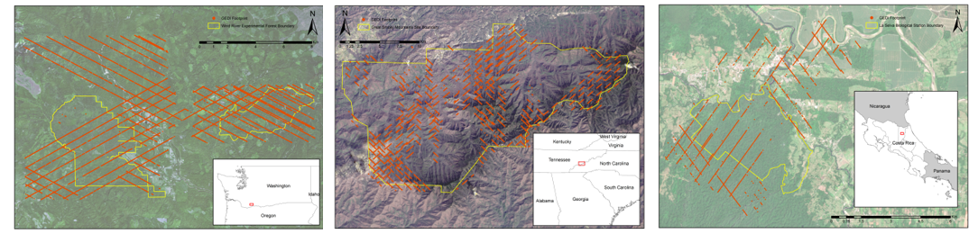
Figure 2: Distribution of all GEDI footprints that could be successfully collocated for each study site (left to right - WREF, GRSM, LSBS). Background images are Sentinel-2 scenes (WREF and LSBS) and a Landsat-8 scene (GRSM). Click on image to open larger figure in a new window.
Methods:
To answer the first research question, ground elevations from GEDI footprint L2A data files were compared to collocated ALS data, as a function of canopy height, canopy cover, and slope. This work utilised the GEDI Simulator (Hancock et al., 2019) and dedicated Python scripts.
To answer the second research question, the Random Forest machine learning algorithm (Breiman, 2001) and Scikit-learn Python package were used to try and predict canopy height from Sentinel-2 imagery. From this prediction, potentially inaccurate waveforms were identified, and new ground elevation estimates calculated. This work relied on additional custom Python scripts.
The GEDI Simulator code can be found here and all other Python and shell scripts can be found here.