
Accuracy of GEDI Lidar Ground Elevation Estimates and an Assessment of the Potential of Machine Learning to Improve Ground and Biomass Estimates
Euan Mitchell
Introduction:
Earth's forests play a key role in the climate system, sequestering approximately one-third of the carbon released into the atmosphere from the burning of fossil fuels (Friedlingstein et al., 2019). However, there is significant uncertainty around the magnitude of these fluxes, due largely to limited and contradictory information concerning the amount of carbon stored in the world's forests (i.e., aboveground biomass density - AGBD) (e.g., Mitchard et al., 2013).
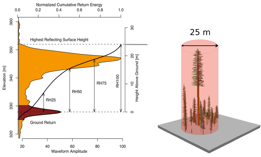
Figure 1: The GEDI lidar emits 242 pulses of near-infrared (1064 nm) radiation every second, which strike Earth's surface as approximately 25 m diameter footprints. The time delay in the received signal ('waveform') reveals information about the ground elevation and overlying forest structure. This example GEDI waveform shows a prominent ground return beneath large amplitude canopy returns. Source: GEDI mission website.
Spaceborne lidar, such as NASA's GEDI (Global Ecosystem Dynamics Investigation) instrument on the International Space Station, is uniquely capable of providing the measurements of 3D forest structure (i.e., canopy height information) necessary to more accurately quantify AGBD of the world's temperate and tropical forests (Dubayah et al., 2020) (Fig. 1). A crucial first step in making these measurements is accurately measuring the ground elevation of each GEDI footprint, as all subsequent measurements and estimates are based on this value.
Research Questions:
This work seeks to answer two questions:
- what is the accuracy of GEDI ground elevation estimates relative to airborne laser scanning (ALS) data across different forest types, and what are the factors that control any biases in the data?
- can ancillary datasets be combined with machine learning to identify and improve inaccurate GEDI ground elevation estimates?