
Project News May 2006
The first three months of 2006 have seen plenty of activity surrounding the Society’s Heritage Lottery Fund (HLF) supported ‘Images for All’ project. Now happily ensconced in the Society’s Boardroom, Candida Fenton (project manager) and Meg Hunter (information officer), are able to begin in earnest the work of cataloguing, conserving and improving access to the Society’s valuable geographical collections.
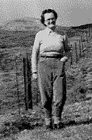
Anna Hanlon, 1948
The Anna Hanlon Collection, featured in the last issue of Geogscot, caught the attention of local radio station SAGA 105.2fm and on Wednesday 29 March, Dr David Munro, Director of the Society, was interviewed about this amazing collection on Dave Marshall’s mid-morning show. We have also been reaching out to members of the Senior Studies Institute in the Centre for Lifelong Learning at the University of Strathclyde, and in early April, contributed two talks to their season of spring seminars. Dr David Munro’s talk “The Scots overseas- from Bruce City in Spitsbergen to Dundee Island in Antarctica” was well received and students enjoyed the opportunity to examine original early maps during Secretary of the HLF Project Management Group, Margaret Wilkes’ talk, “What was that place Great-Gran came from? A look at using early maps for local and family history studies”.
The second major task for project staff in the last three months has been the re-housing of the Society’s collection of early maps of Scotland. This contains original maps dating from the 16th to the 19th century, including maps by famous cartographers such as: Abraham Ortelius (1527-1598); Gerard Mercator (1512-1594); John Leslie (1527-1596) and Herman Moll (1654- 1732). The maps have now been safely re-housed in special protective transparent folders within new metal plan chests. Upgrading of the existing listing of the collection during the re-housing process has improved accessibility and in addition, a third tranche of items has been sent to the Carronvale Bindery in Larbert for conservation.
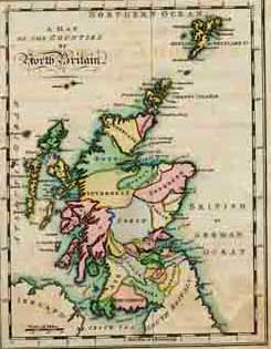
Map of the counties of North Britain
by Mostyn Armstrong, 1794
Amongst the third tranche of items is a copy of the 2nd edition of Mostyn John Armstrong’s Scotch Atlas (1794). As part of the conservation process the volume has been taken down from its binding and we are taking this opportunity to create electronic copies of the maps. Digitisation of the atlas will enable us to provide access to a wider audience and at the same time ensure preservation of the original item.
Within our Early Maps collection we have a particularly stunning collection of 300 early maps which we received in 2000 from the late Perth solicitor, William Cuthbert. Thanks to the HLF grant, the maps are now stored in appropriate conditions to ensure they are preserved for the future. Margaret Wilkes shares her insights into this wonderful collection in the ‘Collections in Focus ’ section of this site.