
The Cuthbert Collection
by Margaret Wilkes
The late William Cuthbert, a well known Perth solicitor and long-term Member of the Royal Scottish Geographical Society, had a deep interest in early maps, particularly those relating to Scotland. After his death, his excellent collection of 300 early maps, 200 of which relate to Scotland, came into the Society's possession in 2000.
As the Convener of RSGS's Library & Information Committee, I looked through this collection with great excitement soon after its arrival at the Society's Headquarters, and made a preliminary list of its contents. Like Mr Cuthbert I too have a fascination with maps, and was lucky enough to spend much of my working life among them, and the thrill of looking through another person's collection, linked to the pleasurable task of examining each sheet in minute detail, was an exhilarating experience. Over many weeks, map after map was taken out of one of the 3 huge portfolios in which his collection had been carefully stored. Each was laid out on a large table, examined carefully, and then listed with great satisfaction, before being returned to the safety and darkness of its portfolio. William Cuthbert must have found similar pleasure in poring over these maps, savouring their content, and pursuing information as to a particular map's origin, its publishing, printing history, and maker.
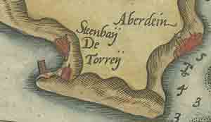
Detail from map of east coast of Scotland,
Lucas Jansz Waghenaer, 1589
William Cuthbert collected not only maps portraying the whole of Scotland, but also maps of a number of the old counties and regions of Scotland, charts of parts of Scotland's coasts, the occasional town plan, and a further motley collection of some 100 maps and charts relating to England, to Europe, and to far-flung parts such as 'the Scots settlement in America called New Caledonia' [i.e. Darien]. While his collection does not encompass all the known early printed maps depicting the whole of Scotland, it contains some important items.
In date the Cuthbert Collection spans some 400 years. The earliest item, a map of Scotland published in 1573, is drawn in what today is perceived as unfamiliar and erroneous form, angled at 90 degrees to England and Wales, and was produced in the Theatrum Orbis Terrarum, or world atlas, of the eminent Flemish mapmaker, Abraham Ortelius. Another more correct - in terms of its geographical outline and angle - map of Scotland produced in Duisberg in 1595 by Ortelius's close friend and rival, the great mathematician and geographer, Gerard Mercator, also features in the collection both in single sheet and two sheet form.
Other important maps and charts of Scotland found in Mr Cuthbert's portfolios added to the pan-European flavour, being produced by French, German, Italian, English and Scottish map and chart makers. A superb, hand-coloured sea chart of the east coast of Scotland from near Berwick upon Tweed to Aberdeen, published in the Low Countries by Lucas Jansz. Waghenaer around 1586, contrasts in style with Robert Dudley's exquisite Italian-produced chart of the same stretch of coastline published some 70 years later. The same stretch of coast is depicted again on a chart published in 1693 by an Englishman, Captain Greenvile Collins, and can be compared with two further charts covering the same area produced in 1703 by the Scottish map and chart maker, John Adair.
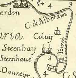
Detail from map of east coast of scotland,
Robert Dudley, 1647
Perhaps the finest 'gem' in the Cuthbert Collection is a large, beautifully wrought, detailed plan of Perth, produced by William MacFarlane in 1792, and engraved by James Kirkwood, of the well-known Edinburgh family of engravers. With the move of RSGS HQ to Perth, projected for 2007-08, Mr Cuthbert's collection will be returning 'home', where it will form a major focal point for the people of Perth and far beyond. The Society's Images for All project, generously funded by the Heritage Lottery Fund (Scotland), is allowing the Cuthbert Collection, and other early maps belonging to the Society, to become more accessible, and some 'gems' from the Cuthbert Collection will be digitised and made available through the 'image gallery' section of this website.