|
|
|||||||||||||||||||||||||||||||
|
Analysing
feature-tracking methods to derive flow rates at John Evans Glacier, Canadian
High Arctic |
|||||||||||||||||||||||||||||||
|
William D. Harcourt |
|||||||||||||||||||||||||||||||
|
Introduction Recent
climatic change in the Arctic has been amplified due to the reduction in sea
ice extent, which accelerates the positive ice-albedo feedback, and enhances
warming in the northern hemisphere high latitudes. In the Queen Elizabeth
Islands (QEI), which contain 14% of the ice covered area outside of Greenland
and Antarctica, accelerated mass loss has been attributed to a persistently
negative mass balance. While this is mainly attributed to the dynamic
acceleration of marine-terminating glaciers (van Wychen
et al., 2016; Harcourt et al., in review), while significant surface melt in
response to elevated summer temperatures has been observed, affecting the
flow rates of land-terminating glaciers. However, the mechanisms responsible
for the changes observed across the region remain unclear, and there is a
pressing need for more robust methods to derive ice flow estimates. Quantifying
the velocity of glaciers is a first order constraint on understanding changes
in ice discharge, as well as long- and short-term changes in ice dynamics.
Estimating glacier velocity has been undertaken using both optical and Radar
satellites, so that velocity results can be obtained on both inter-annual and
intra-annual timescales. Specifically, Synthetic Aperture Radar (SAR) imagery
can be used to track the movement of Radar backscatter, while optical
satellites can be used to measure the displacement of features on the ice
surface using image matching techniques. |
|||||||||||||||||||||||||||||||
|
Key
Objectives Given the need for further systematic comparison of
available feature-tracking techniques, this study had three key objectives: 1)
Analyse whether
a standardised method image pre-processing can be implemented to derive ice
flow on a slow-moving glacier. 2)
Compare and
contrast the effect of automated pre-processing on algorithm choice. 3) Investigate long-term changes in ice dynamics at a land-terminating glaciers in the Canadian High Arctic |
|||||||||||||||||||||||||||||||
|
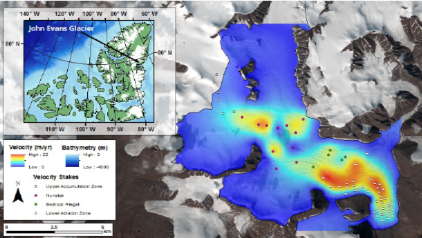
Methods
and Study Site John Evans Glacier (JEG) covers 165 km2
of ice, 0.15% of the total ice covered area across the QEI (Fig. 1). This
site was chosen because of the availability of field velocity from 2000
(Bingham et al., 2003), which is used as a validation dataset for the
feature-tracking analysis.
Three
algorithms were chosen for the comparison based on the use in the literature
(Table 1). Each of these implement one or more of the following image
matching methods; Oriented Correlation (OC), Normalised Cross-Correlation
(NCC), and Phase Correlation (PC). Image
pre-processing followed the automated workflow of Dehecq
et al. (2015), which utilise all available Landsat images of JEG to derive an
ice flow estimate. Because of the slow flow rates of JEG (22 m yr-1),
only the 15 m panchromatic band was used, as this was smaller than the
assumed maximum displacement over 1 year. Following
on from the automated processing method of Dehecq
et al. (2015), image pairs are constructed from the same path and row
|
|||||||||||||||||||||||||||||||
|
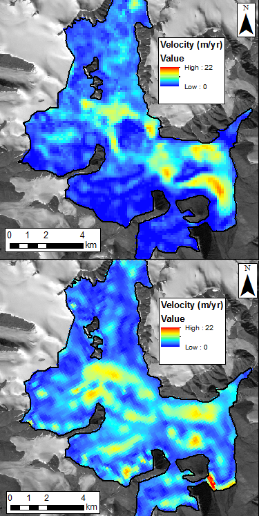
Results
and Discussion The success of each algorithm was assessed based on three criteria; the RMSE with respect with the field results (Bingham et al., 2003), the movement over assumed stable bedrock, and the coherence of the velocity results (Table 2).
It is shown that the ImGRAFT PC algorithm (automated within Dehecq et al., 2015), works best, however the CIAS OC method achieves the best RMSE with respect to the field results. However, COSI-corr produces less deviation over bedrock, suggesting that the algorithm has little background noise. Regression analysis (not shown here) of the field and feature-tracking results show that each merged velocity result underestimates true ice surface displacement, which may be an artefact of a median fusion filter on a small set of image pairs. The ImGRAFT PC method was thus used to derive an estimate of 2013/14 velocity (Fig. 3), showing a decrease in velocity by 1.73 m yr-1 over the 14 year period. This is concurrent with a reduction in ice thickness as shown by airborne geophysical surveys, suggesting that ice flow is reducing as a result of reduced driving stress, as well as being affected by surface melt due to the spatially coherent flow regime (Fig. 3).
|
|||||||||||||||||||||||||||||||
|
Conclusion The results drew the following conclusions: · An automated pre-processing chain is sensitive to algorithm choice, however individual steps are not sensitive to the parameters used. · Algorithms using Fourier-based methods (COSI-corr and ImGRAFT PC) achieve better results at JEG most likely due to the small changes observed. · JEG shows a slowing down of ice displacement, both in response to surface melt and reduce ice discharge. Future studies
should consider the following: · Understand the local environmental conditions, and apply algorithms based upon pre-determined displacement measurements · Understand the changing nature of land-terminating glaciers, and their sensitivity to climate-induced changes. |