
Development of a Web Geospatial Query Interface for Unlock Places API
by Georgia Tzovla, August 2014
Overview
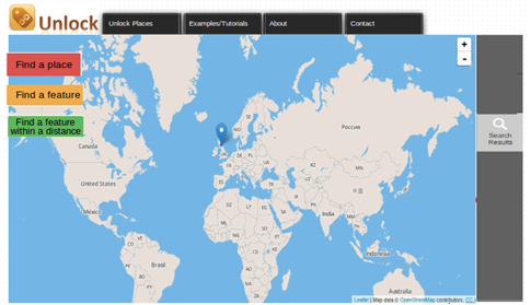
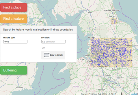
The multitude of spatial data in combination with the rapid growth of Internet technology set Human Computer Interaction (HCI) methods as a core component of the online geospatial development process. Considering the increasing number of people that can access online GIS services, a user-friendly and intuitive interface that allows an easy and effective interaction is essential.This study aims to examine and apply Human Computer Interaction methods in GIS, for the implementation of a geospatial query interface of the Unlock Places service. Unlock Places is a web service implemented by EDINA that combines spatial data from different data sources but does not provide an interface to give the opportunity to non-experts to interact with the service and exploit its possibilities. Following HCI methods, including User-Centred Design (UCD) approaches, users' requirements are identify and according to them interface prototypes are built that through a refinement process they lead to the final design.The implementation is based on JavaScript and especially Leaflet, which is an opensource library for interactive maps.
The final map interface is available here
Also, the code is available at github
Methodology
In order to start developing the user interface we need to link the human intentions with the available map technologies. Therefore the methodology that was followed for the Unlock Places’ interface development includes the following steps:

Conclusion
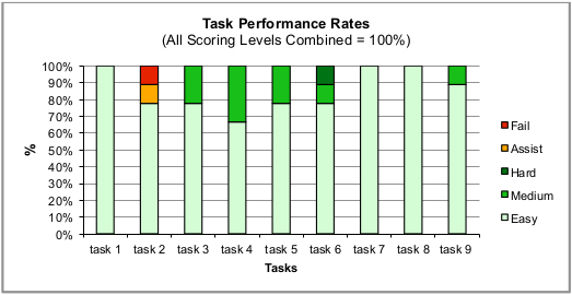
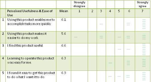
Clear guidelines and design standards for both GIS and non-GIS web pages were followed in order to succeed a direct interaction design.Clear functionality buttons, easy layer manipulation and tutorial examples simplify the procedure, especially for those who are less experienced and have the need for anintuitive and trustful spatial service. Overall, the map’s presentation affected positively the users’ interaction and succeeded to present directly all the available functionalitiesReferences
Cooper, A., 1999. The inmates are running the asylum. Indianapolis: SAMS PublishingGarrett, J. J., 2010.The Elements of User Experience: User-centered design for the web and beyond (2nd ed.). Berkley: New Riders
Haklay, M.,Zafiri, A., 2008. Usability Engineering for GIS: Learning from a Screenshot.The Cartographic Journal.45(2), pp.87–97.
Idoughi, D., Seffah, A., Kolski, C., 2001. Adding user experience into the interactive service design loop: a persona-based approach. Behaviour & Information Technology.31(3), pp.287-303.
Ingensand, J.,2010.User interaction with online geospatial systems, Thesis Ph.D.EcolePolytechnique Fédérale de Lausanne (EPFL)
Marcus, A., 2011.Design, user experience, and usability:theory, methods, tools and practice. First International Conference DUXU Orlando USA, Berlin; New York: Springer.
Mulder, S.,and Yaar, Z., 2007.The user is always right: a practical guide to creating and using personas for the Web.Berkeley: New Riders
Nielsen, J., 1993. Usability Engineering., London: Academic Press.
Nielsen, J., 1994. Usability inspection methods.In Proceedings of the Human Factors in Computing Systems Conference,Boston USA,pp.413–414.
Nielsen, J., 2012.Introduction to Usability. Available at :
Nivala, A-M., Sarjakoski, L.T., Sarjakoski, T., 2007. Usability methods’ familiarity among map application developers. International Journal of Human-Computer Studies, 65(9), pp.784-795.
Nivala, A-M., Brewster, S. and Sarjakoski, L.T., 2008, Usability Evaluation on Web Mapping Sites. Proceedings of the 23rd International Cartographic Conference
Skarlatidou, A., Cheng, T., and Haklay, M., 2013.Guidelines for trust interface design for public engagement Web GIS, International Journal Of Geographical Information Science, 27(8), pp. 1668-1687.
Skarlatidou, A., 2010. Web-mapping applications and HCI considerations for their design, In M. Haklay (ed.) Interacting with Geospatial Technologies,Chichester: Wiley-Blackwell.
Skarlatidou, A. and Haklay, M., 2006.Public Web Mapping: Preliminary Usability Evaluation. Proceedings of GIS Research,UK Conference, Nottingham.
Sue, V. M. and Ritter, L. A., 2012.Conducting Online Surveys.Sage.