|
|
||||||||||||||||||||||||||||||||||||||||||||||||||||||||||||||||||||||||||||||||
|
Utilizing a data integration approach to analyse the
nature of homicide crimes in the cities of Edinburgh and Glasgow throughout
the past century. |
||||||||||||||||||||||||||||||||||||||||||||||||||||||||||||||||||||||||||||||||
|
Alison Rourke-McBride |
||||||||||||||||||||||||||||||||||||||||||||||||||||||||||||||||||||||||||||||||
|
Abstract This dissertation used a data integration approach
to study the nature of homicide crimes in the cities of Edinburgh and Glasgow
over the past century (between 1910 and 2010). Archive records of high court trials and
media sources were used to obtain the specific geographic location of
homicide crimes. 226 homicide crimes
for Edinburgh were digitized and 451 for Glasgow. The data analysis phase of the project
assessed the data from both exploratory and confirmatory perspectives. Hot spot analysis using Nearest Neighbour
Hierarchical Clustering (Nnh) has shown significant temporal trends in the
clustering of homicide hot spots in both Edinburgh and Glasgow throughout the
past century. Regression analysis was
then applied to explore the relationship between homicide crimes and two
recognized material deprivation indexes, the Townsend Index and the Carstairs
Index. Results have shown a weak but
positive relationship with both indexes. Research
Question 1: What is the spatial distribution of homicide crimes
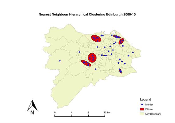
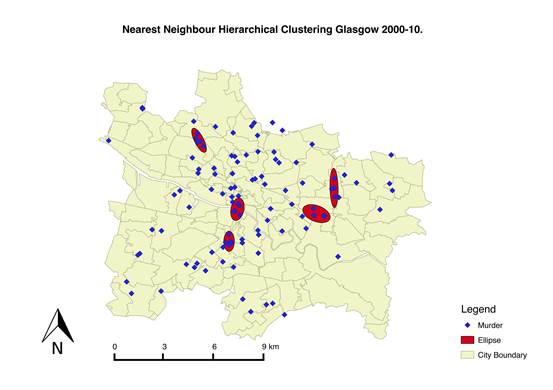
in the cities of Edinburgh and Glasgow? Nnh was applied to the 2000-10 homicide data sets for
both Edinburgh and Glasgow, the results are shown in Figures 1 and 2. Seven first order clusters were found for
Edinburgh and overall the dataset showed statistically significant
clustering. The results for Glasgow also showed a high
level of clustering in this decade, however, the Monte Carlo test showed that
there was more chance that this was down to random variability.
Figure 1 Nearest Neighbour Hierarchical Clustering for Edinburgh 2000-10. Clusters are represented by ellipses shown in red. The precise location of murders are shown in blue.
Figure 2 Nearest Neighbour Hierarchical Clustering for Glasgow 2000-10. Clusters are represented by ellipses shown
in red. The precise location of
murders are shown in blue. Research Question 2: Do
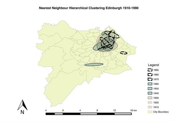
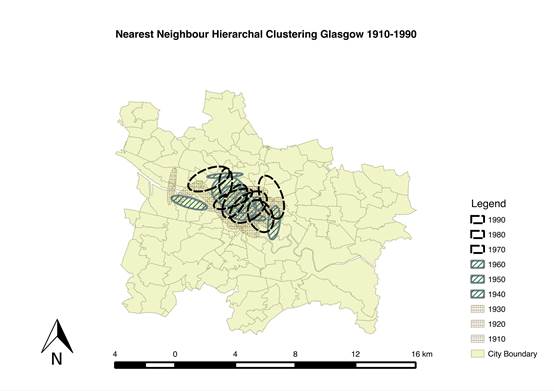
these clusters, if any, stay the same throughout the study period? This research question attempted to assess whether
the geographic distribution of the current homicide crimes analyzed in
research question 1 were consistent throughout the study period. Nnh analysis
was applied to the homicide data for each decade from 1910 to 1990 for both
Edinburgh and Glasgow. The ellipses
showing clusters for each decade were overlaid on top of each other to assess
the distribution of homicide hot spots over the past century.
Figure 3 Ellipses showing clustering of homicide crimes in Edinburgh between 1910 and 1990. The results show considerable temporal trends in the
spatial distribution of hot spots for both cities. In Edinburgh clustering of hot spots
spanned from the east end of the city center towards Leith, in Glasgow the
distribution was concentrated around the city center and surrounding areas. These
results reflect in a more literal sense with Loic Wacquant (2009)’s concept
of territorial stigmatization. They suggest that an area with high homicide
rates is maintained throughout time in a non-cyclical process, in the same
way perceptions of crime can become entrenched in an area.
Figure 4 Ellipses showing clusters of homicide crimes in Glasgow between 1910 and 1990. Research Question 3: Is there a statistical
association between crimes of homicide and indicators of deprivation? Research
question 3 attempted to build upon the results from research questions 1 and
2 by using regression analysis to assess whether there is a statistical
correlation between homicide crimes and material deprivation. This question
was formulated by taking into account the ideas of social disorganisation
theory, which is at the forefront of crime analysis theory (Cahill and
Mulligan, 2007). Previous studies on
homicide have effectively established a correlation between homicide crimes
and inequality, material deprivation or socio-economic deprivation (Ye and
Wu, 2011, Ceccato, 2008, Messner et al., 2013). OLS was
applied from 1970 to 2000 using the Townsend and Carstairs indexes of
material deprivation as the explanatory variable. The results show a weak but
positive relationship between homicide rate and material deprivation (See
Table 1 and 2). With further
investigation it was established that male unemployment had a more
significant correlation with the homicide crimes (See Table 3). Table 1 OLS Coefficient results for Edinburgh 1970-2000. * p<95%.
Table 2 Coefficient results for Glasgow 1970-2000. (* = p< 95%)
Table 3 OLS coefficient estimates for Edinburgh and Glasgow male unemployment as a deprivation indicator. (*=p<95%)
Conclusions This
dissertation offers a new perspective on the spatial determinants of homicide
crimes in Scotland. It has shown that
there is significant potential to increase the understanding of these crimes
through the application of GIS methods. Hot spot analysis
has highlighted prominent spatial patterns to the distribution of homicide
crimes and that this pattern remained consistent throughout the past century
in both Edinburgh and Glasgow. Although
having not been able to establish a strong correlation between homicide and
material deprivation, this dissertation offers a contribution to the study of
homicide crime in Scotland. It
provides a basis for further investigation and the potential to assist in the
prevention of homicide crime. Key References CARSTAIRS,
V. M., RUSSELL 1991. Which Deprivation? A Comparison of Selected Deprivation
Indexes. 13, 318-326. CECCATO,
V. 2008. Expressive Crimes in Post‐Socialist
States of Estonia, Latvia and Lithuania1. Journal of Scandinavian Studies in
Criminology and Crime Prevention, 9, 2-30. MCCALL,
P. L., PARKER, K. F. & MACDONALD, J. M. 2008. The dynamic relationship
between homicide rates and social, economic, and political factors from 1970
to 2000. Social Science Research,
37, 721-735. MESSNER,
S. F., TESKE, R. H. C., BALLER, R. D. & THOME, H. 2013. Structural
Covariates of Violent Crime Rates in Germany: Exploratory Spatial Analyses of
Kreise. Justice Quarterly, 30, 1015-1041. TOWNSEND,
P., PHILLIMORE, P. & BEATTIE, A. 1988. Health and deprivation : inequality and the North / Peter Townsend,
Peter Phillimore and Alastair Beattie, London ; New York : Croom Helm,
[1988], ©1988. WACQUANT,
L. 2009. TERRITORIAL STIGMATIZATION IN THE AGE OF ADVANCED MARGINALITY.
Protosociology: An International Journal of Interdisciplinary Research, 26,
213-225. WANG,
F. & ARNOLD, M. T. 2008. Localized income inequality, concentrated
disadvantage and homicide. Applied
Geography, 28, 259-270. YE, X.
& WU, L. 2011. Analyzing the dynamics of homicide patterns in Chicago:
ESDA and spatial panel approaches. Applied
Geography, 31, 800-807. |